The Dawn of Dynamic Earth: How Drones, Satellites, and Time-Lapse Cameras Are Unveiling Nature\'s Next Great Wonders
The traditional lens through which humanity has observed the natural world, characterized by fleeting glimpses and localized studies, is undergoing a profound and revolutionary transformation. For centuries, our understanding of Earth\'s intricate ecosystems and grand geological narratives has been pieced together through the painstaking efforts of intrepid explorers, dedicated field researchers, and occasional, invaluable snapshots. While these methods have yielded immense knowledge, they have often been limited by the constraints of human presence, immediate perception, and the sheer vastness of our planet. However, we stand on the precipice of a new era of scientific discovery, one powered by the relentless, unwavering gaze of modern remote and automated observation systems. Satellites orbiting high above, nimble drones navigating our landscapes, and time-lapse cameras meticulously documenting fleeting moments are collectively ushering in a paradigm shift, enabling scientists to continuously record, measure, and analyze Earth\'s ever-changing face with unprecedented granularity and scope. This is not merely an upgrade in our observational toolkit; it is a fundamental redefinition of how we perceive and understand our planet, moving us from the static realm of snapshots to the dynamic, trend-based analyses that promise to reveal nature\'s next great wonders.
This transformative surge in our observational capabilities stems from the convergence of several key technological advancements. The miniaturization and increasing affordability of sophisticated sensors, coupled with remarkable leaps in data processing power and satellite communication, have democratized access to powerful monitoring tools. What was once the exclusive domain of national space agencies and well-funded research institutions is now within the reach of a wider scientific community, fostering innovation and accelerating the pace of discovery.
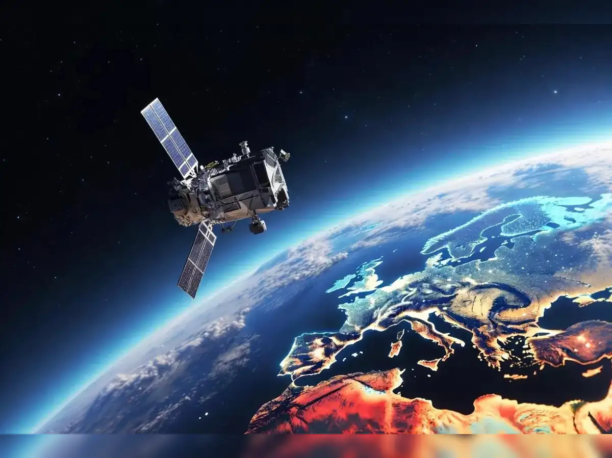
At the vanguard of this revolution are Earth-observing satellites. These sophisticated instruments, meticulously designed and deployed in orbits that allow them to survey vast swathes of the planet, have become indispensable eyes in the sky. Their ability to provide consistent, global coverage over extended periods allows scientists to track large-scale phenomena that were once impossible to monitor effectively. Imagine, for instance, understanding the intricate dance of polar ice caps – their gradual retreat, their seasonal fluctuations, and the subtle shifts in their mass – not through occasional expeditions to the Arctic or Antarctic, but through a continuous, high-resolution stream of data from satellites like NASA\'s ICESat-2 or the European Space Agency\'s CryoSat-2. These missions are not just taking pictures; they are meticulously measuring elevation, ice thickness, and the rate of melting, providing irrefutable evidence for the accelerating impacts of climate change.
Beyond the poles, satellites are revolutionizing our understanding of global deforestation. Nations and researchers can now monitor the clearing of rainforests in real-time using instruments like the Moderate Resolution Imaging Spectroradiometer (MODIS) or the Operational Land Imager (OLI) on board Landsat satellites. These sensors can detect changes in vegetation cover, monitor fire hotspots, and even estimate the carbon sequestration potential of different forest types. This data is crucial for informing conservation efforts, tracking illegal logging, and holding industries accountable for their environmental footprint. The ability to see deforestation not as isolated incidents but as a continuous, dynamic process unfolding across continents is a stark and powerful revelation, empowering proactive interventions rather than reactive responses.
Furthermore, satellite imagery has become indispensable for monitoring agricultural productivity and food security. By analyzing the spectral signatures of crops – how they reflect and absorb different wavelengths of light – scientists can assess plant health, predict yields, and identify areas at risk of drought or disease. This information is vital for optimizing resource allocation, developing resilient agricultural practices, and ensuring that food supplies can meet the demands of a growing global population. The subtle changes in crop vigor, detectable by satellites weeks or months before they become visible to the human eye, allow for timely interventions that can avert widespread crop failure.
The spectral capabilities of these satellites extend far beyond mere visual observation. Hyperspectral sensors, for instance, can capture hundreds of narrow spectral bands, allowing for the identification of specific minerals, water quality parameters, and even the physiological stress of individual plants. This level of detail unlocks new avenues for understanding complex ecological interactions and identifying subtle signs of environmental degradation that would otherwise go unnoticed.
Complementing the broad, overarching view provided by satellites are drones, or Unmanned Aerial Vehicles (UAVs). These agile and increasingly sophisticated machines offer a level of flexibility and proximity that satellites simply cannot match. Drones can be deployed rapidly to investigate specific environmental events, such as oil spills, wildfire hotspots, or areas affected by natural disasters. They can hover over a specific location, capturing high-resolution imagery and video, and even carrying a variety of sensors, including thermal cameras, multispectral imagers, and lidar (Light Detection and Ranging) systems.
The application of drones in ecological research is rapidly expanding. Researchers are using them to map intricate forest canopies, monitor populations of elusive wildlife, and assess the health of coral reefs. In remote or difficult-to-access areas, drones provide a safe and efficient alternative to traditional fieldwork, enabling scientists to collect data from previously inaccessible locations. For example, understanding the microclimates within a dense jungle or surveying the breeding grounds of seabirds on remote islands becomes logistically feasible with drone technology. The ability to get up close and personal with environmental phenomena, while maintaining a safe distance, is a game-changer for many research disciplines.
Lidar, in particular, mounted on drones or aircraft, is revolutionizing our ability to understand three-dimensional forest structure. By emitting laser pulses and measuring the time it takes for them to return, lidar can create highly detailed topographical maps and precisely map the height, density, and biomass of trees. This information is crucial for understanding forest carbon stocks, predicting wildfire behavior, and assessing habitat suitability for various species. The ability to penetrate the forest canopy and map the ground beneath, or to delineate the intricate branching patterns of individual trees, provides a level of ecological detail previously unimaginable.
Furthermore, drones are proving invaluable for rapid environmental assessment following natural disasters. Following an earthquake, flood, or hurricane, drones can quickly survey damaged areas, map the extent of destruction, and identify areas in need of immediate assistance. This real-time situational awareness allows for more efficient deployment of emergency services and a faster, more targeted response to humanitarian crises. The ability to see the full scope of destruction from above, with detailed imagery, allows for better planning of recovery efforts.
The third pillar of this observational revolution is the humble yet powerful time-lapse camera. While seemingly simpler in its functionality, the time-lapse camera offers an unparalleled ability to capture the slow, gradual, and often imperceptible changes that define many natural processes. By taking images at regular intervals – from minutes to hours, days, or even months – these cameras compress vast stretches of time into easily digestible visual narratives. This allows scientists to observe phenomena that unfold too slowly for the human eye to register, revealing patterns and dynamics that would otherwise remain hidden.
One of the most compelling applications of time-lapse photography is in the study of glacial dynamics. Observing a glacier over weeks, months, or years through time-lapse footage reveals its subtle yet persistent movement, the calving of icebergs, and the gradual erosion of the landscape. This provides direct visual evidence of glacial retreat, a critical indicator of climate change, and allows for more accurate modeling of future ice loss. The visual impact of seeing a glacier visibly shrink and recede over relatively short periods can be a powerful tool for public awareness and scientific understanding.
Similarly, time-lapse cameras are transforming our understanding of plant growth and phenology – the study of cyclic and seasonal natural phenomena, especially in relation to climate and plant and animal life. By documenting the germination of seeds, the unfolding of leaves, the blooming of flowers, and the shedding of fruit, researchers can precisely track the timing of these events, which are highly sensitive to environmental conditions. This data is crucial for understanding how plant communities are responding to climate change, how pollination cycles are being affected, and how agricultural practices might need to adapt. The subtle shift in the timing of spring bloom, or the earlier onset of leaf fall, when viewed in a time-lapse sequence, becomes an undeniable testament to changing environmental cues.
The study of coastal erosion and landscape evolution also benefits immensely from time-lapse observation. Cameras strategically placed along coastlines can document the gradual reshaping of beaches, the encroachment of the sea, and the impact of storms over time. This data is vital for coastal management, informing decisions about infrastructure development, dune restoration, and the protection of vulnerable communities. The slow but relentless march of erosion, captured in a time-lapse sequence, highlights the dynamic nature of our coastlines and the need for adaptive strategies.
Beyond these large-scale phenomena, time-lapse cameras are also revealing the intricate workings of smaller-scale ecological processes. Observing the decomposition of organic matter in soil, the behavior of insect colonies, or the subtle movements of geological formations over extended periods offers new insights into the complex interplay of life and earth processes. The hidden world of microorganisms, for instance, can be revealed through time-lapse microscopy, showcasing their growth, movement, and interactions in ways that static observation cannot.
The true power of these emerging observational systems lies not in their individual capabilities, but in their synergistic integration. When data from satellites, drones, and time-lapse cameras are combined and analyzed, they create a richer, more nuanced understanding of Earth\'s systems. For example, satellite data can identify broad areas of forest degradation, drones can then be deployed to conduct detailed surveys of specific affected regions, and time-lapse cameras can document the process of regrowth or further decline in those localized areas. This multi-scalar approach allows scientists to connect the global to the local, the immediate to the long-term, and the visible to the invisible.
This shift from snapshots to trend-based analysis is arguably the most significant consequence of this technological revolution. Historically, much of our understanding of natural processes has been based on periodic measurements or observations at specific points in time. While valuable, these snapshots often miss the subtle but crucial trends that indicate larger, more profound changes. By providing continuous, long-term datasets, satellites, drones, and time-lapse cameras allow scientists to identify and quantify these trends with unprecedented accuracy.
Consider the concept of \"ecological drift\" – the gradual, often imperceptible alteration of ecosystems over time. Without continuous monitoring, such drift can go unnoticed until significant ecological shifts have occurred, making remediation much more difficult. Modern observational tools allow us to detect these subtle shifts early, providing opportunities for targeted interventions and a more proactive approach to conservation and environmental management.
This also leads to a more honest and dynamic understanding of our planet. Instead of viewing Earth as a relatively static entity punctuated by occasional dramatic events, we are beginning to perceive it as a living, breathing, and constantly evolving system. The slow creep of desertification, the gradual warming of ocean currents, the subtle shifts in bird migration patterns – these are not isolated incidents but ongoing processes that contribute to the dynamic equilibrium of our planet. By revealing these underlying trends, these technologies offer a more realistic and scientifically grounded perspective on Earth\'s processes.
The implications of this new era of observation are far-reaching. In climate science, the continuous monitoring of greenhouse gas concentrations, sea-level rise, and ice melt provides the undeniable evidence needed to inform global policy and drive mitigation efforts. The ability to track the precise impact of human activities on atmospheric composition and terrestrial ecosystems, with detailed geographical and temporal resolution, leaves little room for doubt or denial.
In biodiversity research, these tools are enabling scientists to map species distributions with greater accuracy, track population declines, and identify critical habitats. The ability to monitor entire landscapes, and to detect the subtle changes that affect species survival, is crucial for developing effective conservation strategies in a rapidly changing world. Understanding how habitat fragmentation, driven by land-use change, impacts the movement and survival of wide-ranging species is a prime example of this.
For geologists and geophysicists, the continuous monitoring of volcanic activity, seismic events, and the movement of tectonic plates offers the potential for improved early warning systems and a deeper understanding of Earth\'s internal dynamics. The subtle ground deformation preceding an earthquake, detectable by advanced satellite radar interferometry (InSAR), or the minute changes in a volcano\'s heat signature, observable by thermal sensors, are vital pieces of information.
The accessibility of this data is also a crucial aspect of this transformation. Open data policies and the development of user-friendly platforms are making it easier for scientists worldwide to access and utilize satellite imagery, drone data, and time-lapse records. This democratizes scientific inquiry, fostering collaboration and accelerating the pace of discovery by enabling researchers to build upon the work of others. The power of crowdsourcing scientific observations is also being realized, as citizen scientists armed with simple time-lapse cameras or smartphone apps can contribute valuable data to larger research projects.
However, this technological leap is not without its challenges. The sheer volume of data generated by these systems is immense, requiring sophisticated data management and analytical tools. Developing algorithms that can effectively process, interpret, and extract meaningful information from this data deluge is a critical ongoing task. Furthermore, ensuring the ethical use of these powerful observational tools, particularly in relation to privacy and surveillance, is paramount.
The future promises even more exciting advancements. The development of smaller, more autonomous drones capable of complex cooperative behaviors, the deployment of constellations of hyperspectral satellites providing near real-time global coverage, and the integration of artificial intelligence and machine learning into data analysis will further amplify our ability to understand and interact with our planet. Imagine swarms of drones collaboratively mapping a vast rainforest, or AI-powered algorithms sifting through petabytes of satellite data to identify emergent ecological patterns invisible to human analysis.
In conclusion, the transformation from static snapshots to dynamic, trend-based analyses, powered by satellites, drones, and time-lapse cameras, represents a profound shift in our relationship with the natural world. These instruments are not just tools for observation; they are portals to a deeper, more nuanced understanding of Earth\'s intricate systems. They are revealing the subtle, dynamic processes that have long operated beyond our immediate perception, promising to unveil nature\'s next great wonders, from the nascent stages of geological formations to the intricate ballet of global climate patterns. As we continue to refine and integrate these technologies, we are not merely documenting our planet; we are learning to truly see it, in all its breathtaking complexity and continuous, awe-inspiring evolution. The next wave of \"nature wonders\" will indeed come from better eyes, and these eyes are looking at our planet with unprecedented clarity, persistence, and detail, ushering in an era of discovery that will redefine our understanding of life on Earth.