
Technology
ONLYOFFICE 10.0 brings AI tools, modular apps, and stronger security to its open-source office suite
October 10, 2026
2,931 views
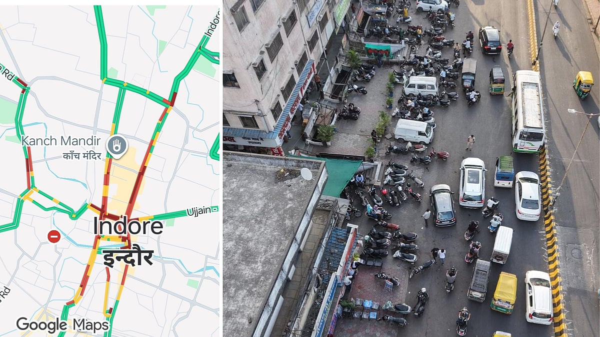
Indore, a bustling city in central India, is taking significant strides to address its growing traffic challenges. With an ever-increasing population and a surge in vehicle ownership, the city has faced severe congestion, particularly during peak hours. To combat these issues, Indore traffic police have turned to technology, deploying drones and utilizing Google Maps' real-time tracking features. This innovative approach is expected to enhance traffic management and ensure smoother transit for residents.
In an effort to streamline traffic flow and enforce no-parking zones, the Indore traffic police have integrated aerial surveillance via drones with advanced mapping technology. The use of drones allows for a bird's-eye view of high-traffic areas, enabling authorities to monitor congestion in real-time. This technological advancement is especially beneficial in locations like Dawa Bazar Road and Regal Square, where traffic bottlenecks are common.
By employing drones, traffic officials can swiftly identify violations such as illegal parking and congestion caused by unauthorized vehicle stopping. This proactive approach not only deters potential offenders but also enhances the overall safety of the roads. The authorities are now better equipped to respond promptly to incidents, ensuring that traffic flows more smoothly across key intersections.
The incorporation of Google Maps' real-time tracking capabilities is another pivotal aspect of this initiative. By leveraging this technology, traffic police can access live data on traffic density, enabling them to make informed decisions regarding traffic management. The colour-coded system implemented in Google Maps provides instant feedback on traffic conditions, highlighting areas of congestion in red and smoother routes in green.
This data-driven approach allows for better coordination among traffic personnel, enabling them to deploy resources where they are most needed. For instance, in moments of peak congestion, additional personnel can be dispatched to redirect traffic or manage crowd control effectively. The goal is to minimize waiting times for commuters and enhance the overall travel experience within the city.
The deployment of drones and the utilization of Google Maps for traffic management come with various advantages. Firstly, it significantly reduces the time taken to respond to traffic violations. Instead of waiting for reports from the ground, officials can now monitor situations in real-time, leading to quicker resolution of issues.
Additionally, the use of aerial surveillance helps in gathering valuable data regarding traffic patterns. This information can be crucial for long-term planning and development of infrastructure. By analyzing traffic flow data, the Indore traffic police can identify persistent problem areas and work on potential solutions such as road widening, new traffic signals, or improved signage.
The integration of drones and mapping technology aligns with broader smart city initiatives being pursued in Indore. As the city aims to modernize its infrastructure and enhance the quality of life for its residents, embracing technological solutions is essential. The ongoing project reflects a commitment to leveraging innovation to tackle urban challenges, particularly in transportation.
Furthermore, these efforts contribute to sustainability goals by promoting efficient traffic management. Reducing congestion not only saves commuters time but also decreases vehicle emissions, supporting environmental sustainability in the region.

Loading more news...
You've reached the end of our news feed. Check back later for more updates!